Multimodal Social Media Data Learning and Visualization for Hurricanes
Research poster presented on CaGIS + UCGIS Symposium 2024
 Download Compressed Image
Download Full-Size Image
This is the poster presentation for CaGIS + UCGIS Symposium 2024.
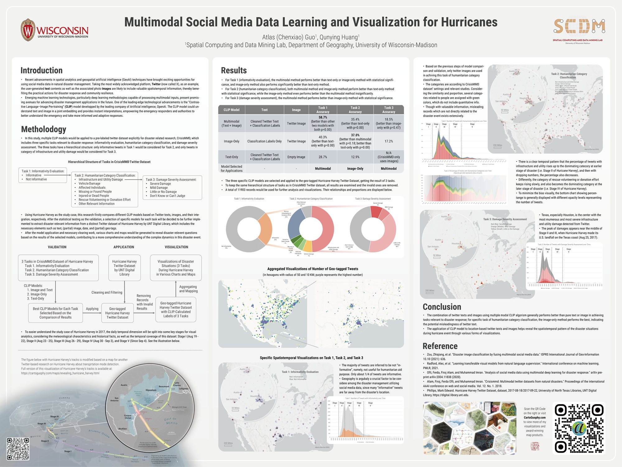
Abstract:
The recent advancements in spatial analytics and geospatial artificial intelligence (GeoAI) have
unveiled new horizons for leveraging social media data in realm of natural disaster
management. Focusing on Twitter (now X), a widely recognized platform, this research highlights how
user-generated textual contents and associated images can offer invaluable
spatiotemporal insights, aiding in disaster response efforts and bolstering community resilience.
Despite the acknowledged potentials of social media data in emergency management,
there is an evident gap in comprehensive studies that integrate GeoAI and cartographic visualizations to
swiftly mine and utilize this data for enhancing situational awareness.
The advent of cutting-edge machine learning technologies, especially those facilitating the processing
of multimodal data, suggest significant prospects for enriching disaster
management applications. A prime example of such innovation is the Contrastive Language–Image
Pre-training (CLIP) model developed by OpenAI, which synergizes text and image analysis
in a unified framework, thus enabling emergency responders and decision makers to gain a deep and more
nuanced understanding of crises for timely and adaptive interventions.
This study employs multiple hurricane incidents to evaluation and compare the effectiveness of various
machine learning models in processing and integrating Twitter’s text and image
data. The findings affirm that the multimodal approach, particularly through the use of the CLIP model,
excels in performing crucial tasks relevant to disaster management such as
informativeness evaluation, humanitarian category classification, and damage severity assessment. After
the validation process, the proposed multimodal method is then implemented to
extract disaster relevant information from a distinct Twitter dataset collected during Hurricane Harvey
in 2017. The enumerated results of tweets, integrated with spatiotemporal
information, are utilized to generate a suite of static and dynamic cartographic visualizations, which
serve to reveal a more comprehensive understanding of the complex dynamics in
this disaster event.
In conclusion, this research demonstrates that the application of CLIP multimodal data mining method
stands out as a powerful tool for integrating the user-generated texts and images
in social media, enhancing the disaster management capabilities by offering crucial information
extractions and cartographic visualizations, paving the way for future advancements in
the field of natural disaster management.