Portfolio
GIVE US THIS DAY OUR DAILY MAP.
Filter by tags (multi-select):
Click to jump to:
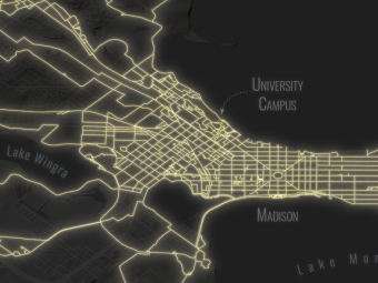
—— Reference Map ——
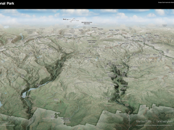
Scenic Yosemite
National Park
A cartographic
tribute to the
birthplace of the
national park
idea
Land Flowing with
Milk and Honey
A non-political and
non-religious map
calling for peace in
Israel and Palestine
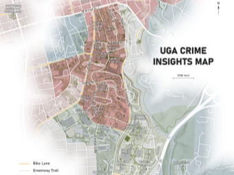
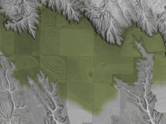
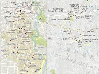
University of Georgia
Campus
Map
with
Safety Rate and
Bike Lane Info
For the application for a
UGA Sustainability Grant
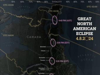
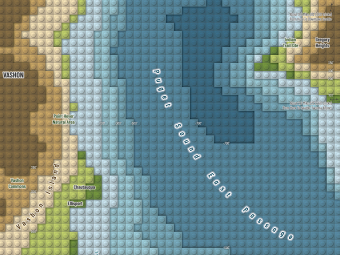
Great North
American Eclipse
on
4.8.2024
1st Place of Student Maps
(University and Postgraduates)
in Esri
UC 2024 Map Gallery
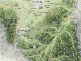
Zibo Map of Culture
and Tourism
Best Cartographic Design in
2023 NACIS Map
Competition;
Atlas of Design Vol.7; Cartography
SIG Excellence Award in Esri UC
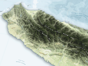
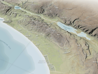
Trilingual Map of
Taiwan,
“Scenic
Formosa Island"
Most Innovative Map and
Cartography Excellent Award
in 2023 Esri
User Conference
—— Multivariate Map ——
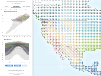
Climate
Visualized
Exploratory webmap
visualizing Köppen-Geiger
climate
classification
with
interactive features
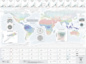
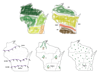
Köppen Climates
Visualized
Comprehensive infographic
of Köppen-Geiger climate
classification
with
monthly
temperature & precipitation
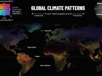
Global Climate
Patterns
Multivariate mapping of
global climate using
WorldClim dataset of
temperature and
precipitation
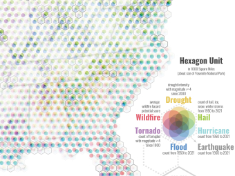
United States of
Rising
Hazards
NACIS 2025 Best Dynamic Map;
Honorable Mention of
Digital Map
Award in
CaGIS Map Competition
United States of
Blooming
Risks
Best Thematic Map
Award in
WLIA
2025 Map
Contest;
Featured in local libraries
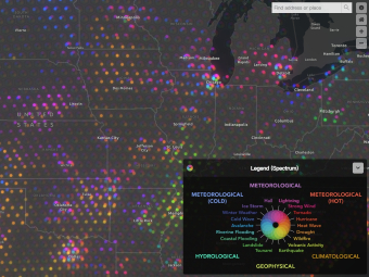
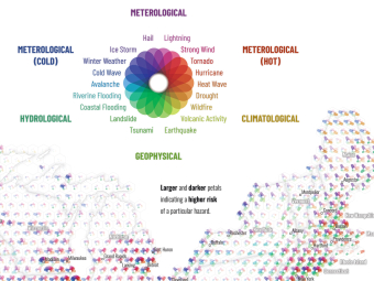
United States of
Natural
Disasters
NACIS 2024 Best Research Map;
Best Cartography Award,
Most
Innovative Map in Esri UC;
Runner-Up in WLIA and BCS
—— Hurricane Map ——
Active
Hurricane
Tracker
A practical web app tracking
global active tropical cyclones
for
emergency use with cartographic
and meteorological considerations
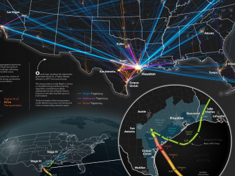
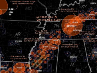
Identifying Places with
Power
Outages after
Hurricane Helene
Based on comparison
of satellite images before
and after the
storm
Multimodal Social
Media Data
Learning
and Visualization
for Hurricanes
Research poster presented on
CaGIS + UCGIS Symposium 2024
Visualizing
Historical
Hurricanes in
Contiguous U.S.
Best Print Map in 2022
CaGIS Map Competition
Revealing
Hurricane
Harvey 2017
Geovisualization of twitter-
based trajectories;
on Esri
Map Book
Vol.39
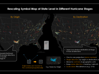
Rescaled Symbol
Design
for
Trajectories
Innovative Twitter-based
visualization of 2017
Hurricane
Harvey
—— Disaster & News Map ——
U.S. Power Outage after
2026
Winter
Storm
Rapid news mapping
practice visualizing
power outages after
Jan
2026 winter
storm
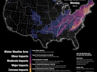
Visualizations on
U.S. Winter Storm
Static maps and web app
visualizing NOAA Winter
Storm Severity
Index
for Jan
2026 storm
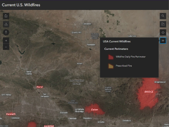
Live U.S. Wildfire
Visualization
Web map visualizing
real-time wildfire
activity across the
U.S.
including
type and area
Map Series of
Global News
Serving MADNEWS articles;
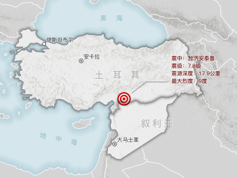
Mapping area includes
Turkey,
Israel/Palestine,
Ukraine, China, Egypt
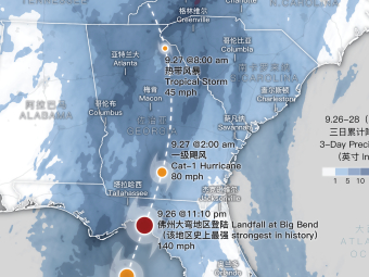
Map Series of
Domestic News
Serving MADNEWS articles;
Mapping area includes
southeastern
U.S.,
Texas,
Oklahoma, entire U.S.
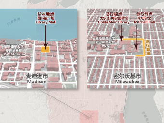
Map Series of
Local News
(Madison
Area)
Serving MADNEWS articles;
Topic includes COVID, assault, event,
administration, political protest
—— LEGO Map ——
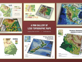
A Mini Gallery
of LEGO
Style
Topographic Maps
Runner-Up of
Mapping
Poster Award in WLIA
2025 Map Contest
Lego Style
Map Quilt
for NACIS
2024
Contributing one
map quilt tile in
Seattle-Tacoma Area
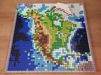
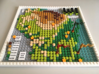
LEGO Map of
North America
Best Student Map in
WLIA
2025 Map Contest;
Collected by American
Geographical Society Library
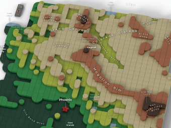
Physical Geography
of Arizona
in
LEGO Style
3D rendered graphics with labels;
winner of college student project,
AGIC Symposium Maps Contest
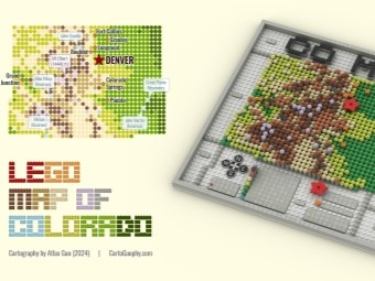
LEGO Map of
Colorado
Winner of Student
Artistic Section in
GISCO Mapping
Contest;
one brick = 10 sq mi
LEGO Map of
Wisconsin
Featured in Esri UC Plenary Session;
Most Unique Map, Best Student
Map,
President’s Choice, People’s
Choice
(Adult) in WLIA 2024 Map Contest
![]() Interested
in seeing more LEGO maps? Check out this LEGO-dedicated
page.
Interested
in seeing more LEGO maps? Check out this LEGO-dedicated
page.
—— Historical Map ——
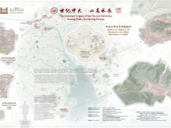
Sun Yat-sen University
(SYSU)
Centenary
Memorial Map
Runner-Up of Reference
Map Award in WLIA
2025 Map Contest
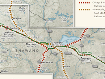
Historic Railroads in
Menominee
and
Shawano Counties, WI
(Grayscale Version) Best Black
and White Map Award in
WLIA
2025 Map Contest
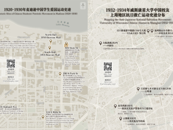
Chinese Badgers
during WWII
at
Madison and
Shanghai
Mapping the stories of
Chinese Badgers at the two
places during
World War II
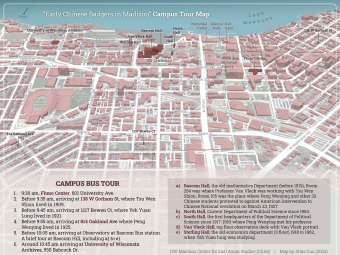
"Early Chinese
Badgers in
Madison"
Campus Tour Map
Guidebook for family members of
past Chinese alumni hosted
by
Center
for East Asian Studies

"Early Chinese
Badgers
(1907-1920)"
Static and Interactive
Map Series
Visualizing hometown and Madison
address of UW Chinese alumni

Map of Lifetime
Footprint
in
Memory of My
Grandfather
Best Black & White Map in WLIA
2024; Grayscale memorial map
—— Web Map ——
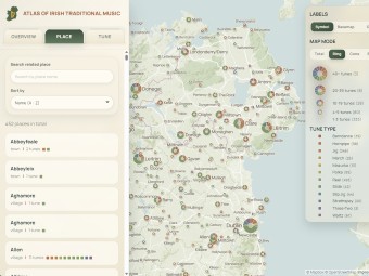
Atlas of Irish
Traditional Music
A web map connecting Irish
traditional tunes with
places,
honorable mention of
17th Digital Salon
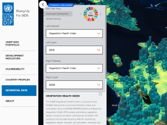
UNDP SIDS
Geospatial
Dashboard
Participated Mapbox-based
web map development
during
internship at UNDP
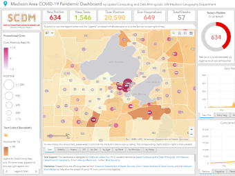
Madison Area
and
Wisconsin
Covid Pandemic
Dashboards
Honorable Mention, Digital Map
Award in CaGIS Map
Competition
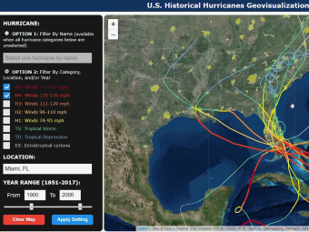
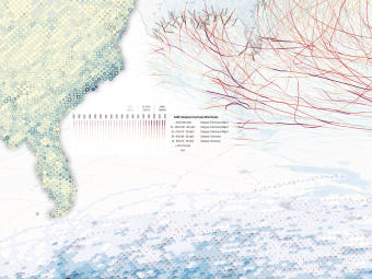
U.S.
Historical
Hurricanes
Geovisualization
Group project of interactive
map application based
on
Leaflet
and D3
package
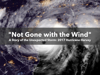
"Not Gone
with the Wind"
Esri
Storymap
A story of the unexpected
Hurricane Harvey using
Esri
StoryMaps
narrative
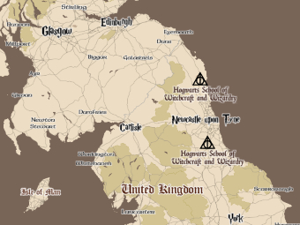
Harry Potter
Themed
Web Map
Mapbox-based customized
web map with H.P. related
sites in
the
U.K.
—— COVID Map ——
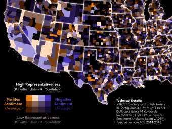
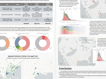
Mapping
Twitter
Sentiments
Towards Covid
Value-by-alpha map of
sentiments with
twitter
representativeness
level
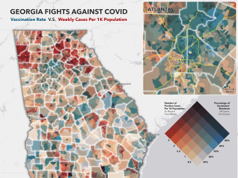
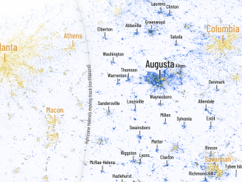
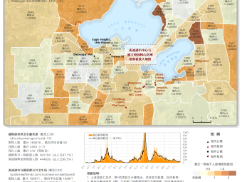
Georgia Fights
Against COVID
Bivariate choropleth map
visualizing the COVID case
per
capita
vs. vaccination
rate in recent week
Mapping Twitter
User
Trajectories
During COVID-19
Exploration with 5 million
trajectories regarding
COVID-19
using
Kepler.gl tool
—— Mapping Activity ——
Multi-Hazard
Map Quilt
for
NACIS
2025
Contributing a tile
visualizing the risks of
multiple natural
hazards
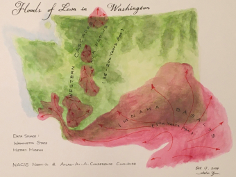
Floods of Lava
in
Washington
(Watercolor)
For Atlas-At-A-Conference event
during NACIS 2024
Conference;
finished
during Night-In Session

Mapping U.S.
Historical
Lynchings
Tangible and digital flow maps
of incident sites and news;
2024 Design Challenge

"The United States
of
Wisconsin"
Re-structure the de-structured
U.S. states into
Wisconsin;
1-hour
map collage activity
during NACIS 2023
Evolution of
the Great Plains
Animations of subtle
topography on surface of
loess
tableland in
Nebraska;
2023 Design Challenge
Thematic Map
Type ABCs
Through
Games
Cartography Curriculum
Design for K5 Education;
2022 Design
Challenge
—— Map Series ——
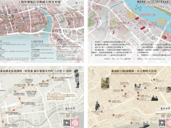
Historical
Map Series
for
"Shanghai Dérive"
Designed for guided tour
of historic sites in Shanghai
(more info on
RedNote)
30-Day Map
Challenge in 2025
30 entries posted on
LinkedIn, Instagram, X & Bluesky
with
#30DayMapChallenge
in November 2025
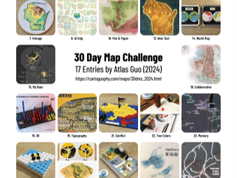
30-Day Map
Challenge in 2024
17 entries posted on
X, Bluesky & LinkedIn with
#30DayMapChallenge
in November 2024
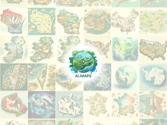
Instagram Account
@AI.MAPS
Posting
AI-Generated Maps
Maps include geographic faults;
simply enjoy but do not
use for reference purpose

Map Products
during Internship
at
Institute for
Local Self-Reliance
67 Static Maps of various
types in multiple projects
Static Map Series
for COVID-19
Pandemics in
Madison Area
Over 800 daily infographics
with maps for MADNEWS
—— Personal Map ——
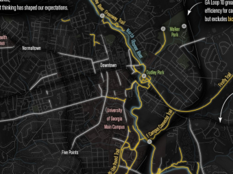
Cyclist Survival
Map of Athens (GA)
Best Overall Map Award
in State of the Map US 2026
Narrative Map
Competition
(OpenStreetMap US and Esri)
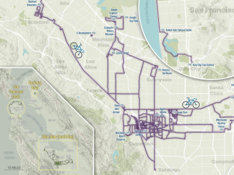
My Summer 2025
On Two Wheels
Mapping distinct
biking routes and
spatial footprints
in the Bay Area
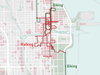
Biking and Walking
Tracks
During 5-Day
Trip at Chicago in
2024 Christmas
Simple map design in Christmas's
theme colors of red and green
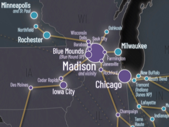
Our Spatial Memories
of the United
States
An abstract network of
personal footprints with
transportation
mode
in
2015-2024
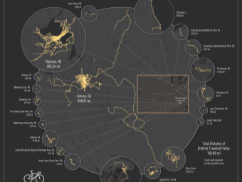
Mapping My Biking
Journey with
Distance
of Distinct
Traveled
Paths
Winner of Mapping
Masterminds
Competition (Maps), ISU GIS Day
Unlock Madison
by Bike
Mapping my yearly
cycling/scooting tracks
in Madison and
vicinity
(Sep 2023 - Aug 2024)
Bilingual Map of
Athens (GA)
and
Vicinity
Practically serving Chinese
student communities at
the
University of Georgia
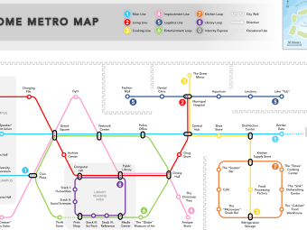
Transit Map Style
"Home Metro
Map"
Innovative graphic design of
transit map in memory of 2020
home
quarantine
days
within apartment unit
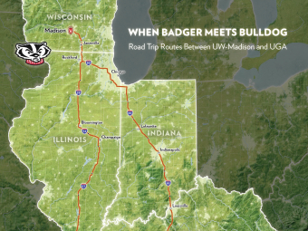
"When Badger
Meets Bulldog"
Personal map product
illustrating my past and future
road
trip
routes between
UW-Madison and UGA
—— Artistic Map ——
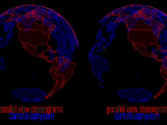
3D Stereoscopic
Maps of Globe
Fun experiments of
chromostereopsis and
Stereogram of 3D Globe
in red and blue
colors
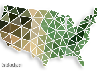
Low-Poly Style
Graphic Design of
Lower
48 U.S.
States
Digital graphic design
with a watercolor
painting version
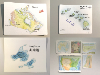
Hand-drawn
Watercolor Maps
with
Calligraphy
Beginner's exercise
painting of
various
places around the world
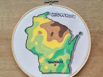
Acrylic Painting of
Wisconsin
Topography
on Hook Art Canvas
Artistic representation of
topography in Wisconsin with
Celtic
style calligraphy

Map-making
in
Seal-Carving
Calligraphy
Engraving maps on seal stone
material as image stamps:
China,
Wisconsin, and Zibo
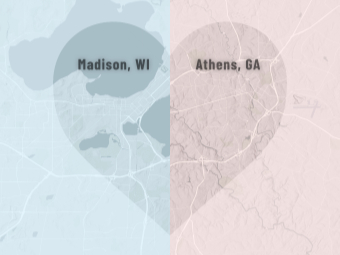
Heart Shape
Dual Maps
Romantic graphic design
of dual cities (both U.S.
and hometown
in China)
with same map scale
—— Craft Map ——
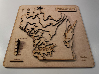
Laser Cut
Wisconsin Map
A laser cut topographic
map of Wisconsin
using HDF board
with 3D
legend
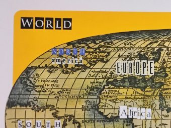
Collage of Antique
World Map
with
Typography
Individual letters from old
magazines forms the
names of all the
continents
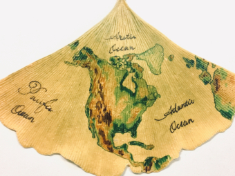
Ginkgo Painting of
North
America
Painted with topographic
color scheme on a
fan-shape ginkgo
leave
under conic projection
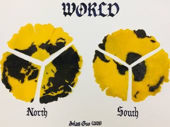
Ginkgo Painting
of World Map
in
Hemispheres
North and south pole maps
under azimuthal projection
with marker
painting
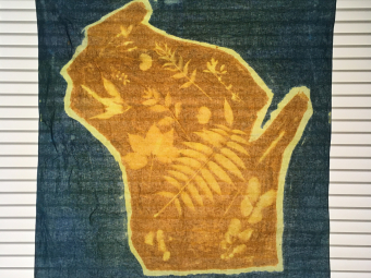
Wisconsin Map
on Solar Printed
Cotton
Bandana
Made with local flowers
and fronds during a
bike-and-craft
activity
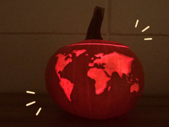
Happy Mappy
Halloween
Maps carved on pumpkins,
including a world map,
Wisconsin,
Georgia,
Madison,
and the Great Lakes
As an "Atlas", I keep enriching myself.